|
Honolulu Advertiser Second Opinion by Cliff Slater March 31, 2003 |
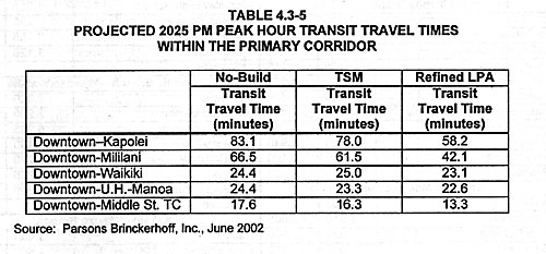
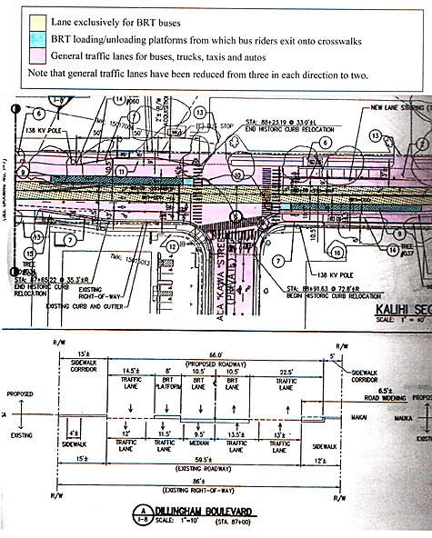
xThe folly of the in-town BRTMany alert readers have asked me, “What is the BRT?” Here’s what it is—and also what it isn’t. BRT is short for Bus/Rapid Transit, and it is the city’s plan for public transportation in the Leeward Corridor. [i] It has two different parts, the regional [ii] and the in-town, [iii] and they would connect at either the Middle Street Transit Center or the Iwilei Transit Center, which is on King Street opposite A’ala Park. All told the capital costs incurred by the city would be $370 million and the balance by the federal government. [iv] The city will pay virtually all the operating costs [v] and any cost overruns in its construction. The regional BRT creates “a continuous H-1 BRT Corridor from Kapolei to downtown using a.m. and p.m. contraflow zipper lanes and express lanes.” [vi] The benefit of this, the city says, is that typical bus travel times from Mililani to downtown, for example, would be cut by 25 minutes.[vii] So far, so good. The in-town BRT, using large hybrid diesel/electric buses, [viii] will run from the Middle Street Transit Center to the Iwilei Transit Center where they split into three branches—one to UH and two to Waikiki (one of which will service the Kakaako Park area). [ix] The city claims the BRT buses will make better time than regular city buses by being able to use certain lanes exclusively—and some semi-exclusively by sharing with buses. These special BRT lanes will be converted from what are currently general traffic lanes. In addition, the BRT buses will have traffic signal priority, which will enable them to prolong green traffic lights. The benefit of the in-town BRT, the city says, is that rush hour bus travel times from downtown to UH would be cut by 1.8 minutes, and downtown to Waikiki by 1.3 minutes. [x] (Pause here to let that sink in.) At the end of this year the city plans to start construction of the total BRT system by first building the in-town line from the Iwilei Transit Center to Waikiki. [xi] After spending significant time with drivers of Honolulu’s delivery vehicles, tour buses and taxis lately, I now understand the strength of their opposition to the in-town BRT. Here’s why: First, that valuable road space is being taken away from regular city buses, truckers and other delivery people, tour bus operators, and taxi drivers to allow the BRT bus to have priority. They believe it will seriously disrupt traffic. For example, the city proposes to reduce:
In addition, the city will have to narrow certain lanes to make room for the special BRT lanes:
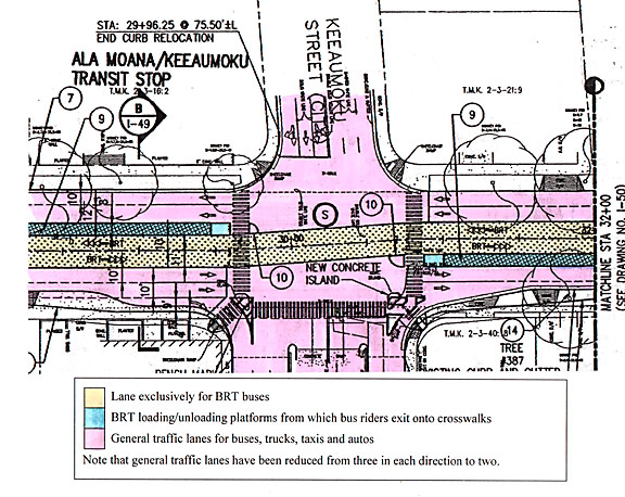
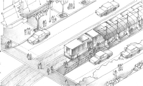
Second, they believe the way the city proposes to handle BRT passengers is going to worsen traffic congestion. For example, on the mauka side of Ala Moana Center today, most bus passengers are loaded and unloaded within the Center itself. The BRT plan calls for these passengers to load/unload onto two platforms—each 160 feet x 8 feet x 13 inches high—in the middle of Kapi'olani Boulevard. These platforms are on either side of Keeaumoku Street will exit onto the existing pedestrian crossings. [xiv] Such center street loading platforms are along Pensacola, Dillingham, University and Kapi'olani. Third, giving traffic signal priority to the BRT buses will throw off the traffic light synchronization—along King Street, for example. Fourth, since the in-town BRT from downtown to Waikiki only offers one-minute savings, why not start with the regional BRT and see if that delivers what the city promises? Riders will have to change buses anyway; why not just transfer onto regular buses if all the BRT saves is one minute? It’s tough to argue with that approach. After all, it is a 25-minute savings for the regional versus a one-minute saving for the in-town. In fact, with such little time-savings one wonders why, with only a minute to be gained, we need to spend all that money, and create such traffic havoc. In fact, why build the in-town section at all? Cliff Slater is a regular columnist whose footnoted columns are at: www.lava.net/cslater. Engineering drawings and other views of the proposed BRT project can be found on that site. |
[i] The Plan is officially known as the Final Environmental Impact Statement for the Primary Corridor Transportation Project.
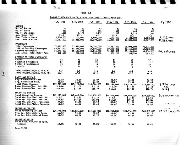
[v] Projected operating costs for the BRT are significantly underestimated. For example, for the year 2025 No-Build Alternative, which is the existing bus system plus 18% more buses, the city projects operating costs for TheBus to be only 3% greater than today in 2002$’s even with a projected 41% more riders. The fact is that for the past 22 years, operating costs have risen 44% in 2002$’s and that is with a 5% decline in riders.
To check these figures you need: For 1981 See 1987 Short Range Transit Update. Honolulu DTS. p. 3-5. The figure of of $42.1 million is $82.1 million in 2002 dollars using Honolulu CPI-U data from Table 14.02 State Data Book 2001. For 2002, see FEIS , page S-8. “It is estimated that O&M costs for the No-Build Alternative in 2025 would be about $121 million (in 2002 dollars). This compares to current operating costs for the existing bus system of about $118 million. Both numbers do not include The Handi-Van operations.”